
Description
Coleraine (; from Irish Cúil Rathain, meaning 'nook of the ferns' [kuːlʲ ˈɾˠahɪnʲ]) is a large town and civil parish near the mouth of the River Bann in County Londonderry, Northern Ireland. It is 55 miles (88.5 km) northwest of Belfast and 30 miles (48.3 km) east of Derry, both of which are linked by major roads and railway connections. It is part of Causeway Coast and Glens district.
Description
Coleraine had a population of 24,630 people in the 2011 Census. Disposable income is well above the Northern Ireland average. The North Coast (Coleraine and Limavady) area has the highest property prices in Northern Ireland, higher even than those of affluent South Belfast. Golf courses, countryside and leisure facilities and attractions are to be found. It has an attractive town centre, and a marina. Coleraine during the day is a busy town, however at night the town is relatively quiet, with much of the nightlife in the area located in the nearby seaside towns of Portrush and Portstewart. Coleraine is also home to the one of the largest Polish communities in Northern Ireland.
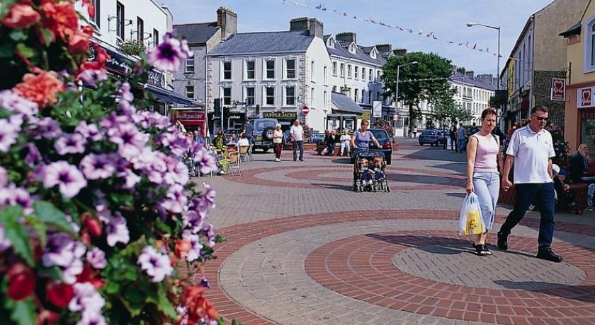
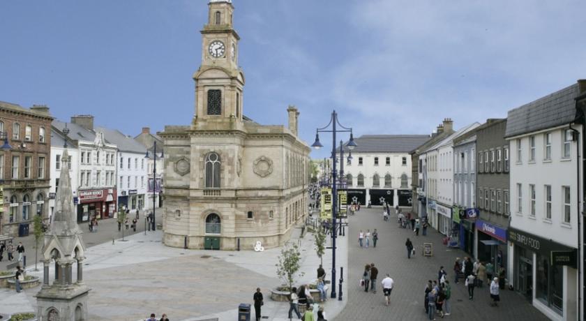
Coleraine is situated at the lowest bridgeable point of the River Bann, where the river is 90 metres wide. The town square is called 'The Diamond' and is the location of the Town Hall. St. Patrick's Church of Ireland is situated nearby. The University of Ulster campus was built in the 1960s and has brought a theatrical space to the town in the form of the Riverside Theatre.
Coleraine has been designated as a major growth area in the Northern Ireland Development Strategy. Although the population of the town is only 25,000, Coleraine has a large catchment area. The town also has the advantage of being near some of the most extraordinary landscape in the whole of Europe. In 2002, Coleraine won the Best Kept Town and Ulster in Bloom awards. In 2003, it was selected to represent Northern Ireland in the prestigious Britain in Bloom competition. In the 2010 SuperValu Best Kept Awards, Coleraine was named the Best Kept Large Town in Northern Ireland, this is a prestigious award which commends towns throughout Northern Ireland for their work to improve the local environment. It has its own local radio station: Q97.2FM
History
Coleraine has a long history of settlement. The Mesolithic site at Mount Sandel, which dates from approximately 5935 BC is some of the earliest evidence of human settlement in Ireland.
The 9th century Hagiography Tripartite Life of Saint Patrick records how the town got its name. When Patrick arrived in the neighbourhood, he was received with great honour and hospitality by the local chieftain, Nadslua, who offered him a piece of ground on which to build a church. The spot was next to the river Bann and was overgrown with ferns, which were being burned by some boys to amuse themselves. This incident led to the area being called Cúil Raithin ("nook of ferns"), which was later anglicised as Colrain, Colerain and Coleraine. It was translated by Colgan into Latin as Secessus Filicis.
The town was one of the two urban communities developed by the London Companies in County Londonderry in the Plantation of Ulster at the start of the 17th century. The slightly skewed street pattern of Coleraine's town centre is legacy of that early exercise in town planning, along with traces of the lines of the ramparts that provided the Plantation town with its defences. In 1637 the Surveyor General of Customs issued a report compiled from accounts of customs due from each port and their "subsidiary creeks". Of the Ulster ports on the list, Carrickfergus was first, followed by Bangor, Donaghadee, and Strangford. Carlingford and Coleraine each had £244 customs due and had equal ranking.
During the War of the Two Kings (1689–91) Coleraine was a centre of Protestant resistance to the rule of James II. Richard Hamilton's Irish Army made an attempt to seize the town, but was repulsed. The Protestants were forced to abandon the town shortly afterwards and withdrew to Derry. Later the same year, following the failed Siege of Derry, Sir Charles Carney and his Jacobite garrison fled the town on receiving news of the advance of Percy Kirke's Enniskillen forces and the landing at Carrickfergus of Marshal Schomberg. The Williamites controlled Coleraine for the remainder of the war.
With some industrialisation, the expansion of the river port, and the development of the railway, the town expanded significantly throughout the 19th century and into the early part of the 20th century. Coleraine steadily expanded after the Second World War. The population doubled due to major industrial development on extensive suburban sites, the decision to site the New University of Ulster (now known as the Ulster University) in the town, the expansion of commerce and the development of sporting and recreational facilities. There has been a steady expansion of the urban area from the mid 20th century compact town of less than 1¼ square miles (2 km²), to the present much more dispersed town of about 7 square miles (11 km²). During the Northern Irish Troubles 13 people were killed in or near Coleraine, ten of them in two separate car bomb explosions.
Since 1980 growth has continued but at a slightly more modest pace. In the twenty years to 2001 the town's population increased by 22% to approximately 25,000 but the rate of increase fell from 12% in the 1980s to 8% in the 1990s.
The Troubles
Governance
Coleraine was the headquarters of the former Coleraine Borough Council, before this was amalgamated in 2015 to form the Causeway Coast and Glens District Council, which is now based in the former Coleraine Borough Council headquarters.
The Borough Council area together with the neighbouring district of Limavady, forms the East Londonderry constituency for elections to the Westminster Parliament and Northern Ireland Assembly, despite some of the borough being in County Antrim.
The Unionist-controlled Coleraine Borough Council operates a rotation for position of Mayor/Deputy Mayor between the Ulster Unionist Party (UUP), Democratic Unionist Party and the nationalist Social Democratic and Labour Party (SDLP).
Tourism
Coleraine is the main town of the world famous Causeway Coast, which attracts over three million visitors per year, spending in excess of £47 million. The world famous Giant's Causeway is a twenty–five-minute bus ride away. The distillery village of Bushmills is well-served by buses from the town and there is a narrow-gauge steam train running in the summer from Bushmills to the Giant's Causeway. The train journey takes approximately fifteen minutes from the town to the Causeway. Also north of Coleraine is the scenic coastal town of Portstewart, with fine sandy beach and coastal walks. Portrush is part of the Borough.
North-west of Coleraine lies the small village of Castlerock, with a beach which is essentially a continuation of the beach at Portstewart, separated by the River Bann. Also nearby is the huge beach at Benone Strand and Mussenden Temple, built by Frederick Augustus Hervey, an 18th-century Anglican bishop atop a precipitate cliff and overlooking County Donegal in one direction and Scotland in another. The National Trust managed Downhill forest was part of the Bishop's Palace, and although the Palace itself is now a ruin the gardens are a wonderful place full of strange hidden lakes and gloriously tended flower gardens.
Climate
As with the rest of the British Isles, Coleraine experiences a maritime climate with cool summers and mild to cold winters. The nearest official Met Office weather station for which online records are available is at nearby Coleraine university, about 1 mile North of the town centre. However, observations ceased a few years ago and the nearest current Met Office weather observing station is at Movanagher, about 12 miles to the south. Rainfall at Coleraine typically peaks at over 100mm during the month of October. The driest month is May, with an average of under 60mm. On average, 173 days of the year will report at least 1mm of rain, ranging from 18 days in January to 11 days during June.
Places of interest
The east side of the town is distinguished by Mountsandel Forest, which contains the Mount Sandel fort, an ancient site which has been claimed as the oldest site of human settlement in Ireland. Here wooden houses dating from about 7000 BC were uncovered. The fort can be accessed via Mountsandel forest, the closest entrance being the side near the Coleraine Courthouse. There is another fort about 2 miles south from Mountsandel one near a small village called the Loughan.
Source: https://en.wikipedia.org/wiki/Coleraine
Address
Coleraine
Irlanda
Lat: 52.944370270 - Lng: -7.660480022

