
Description
Champasak (or Champassak, Champasack – Lao: ຈຳປາສັກ [càmpàːsák]) is a province in southwestern Laos, near the borders with Thailand and Cambodia. It is one of the three principalities that succeeded the Lao kingdom of Lan Xang. In 2005, it had a reported population of 607,333. The capital is Pakse, but it takes its name from Champasak, the former capital of the Kingdom of Champasak.
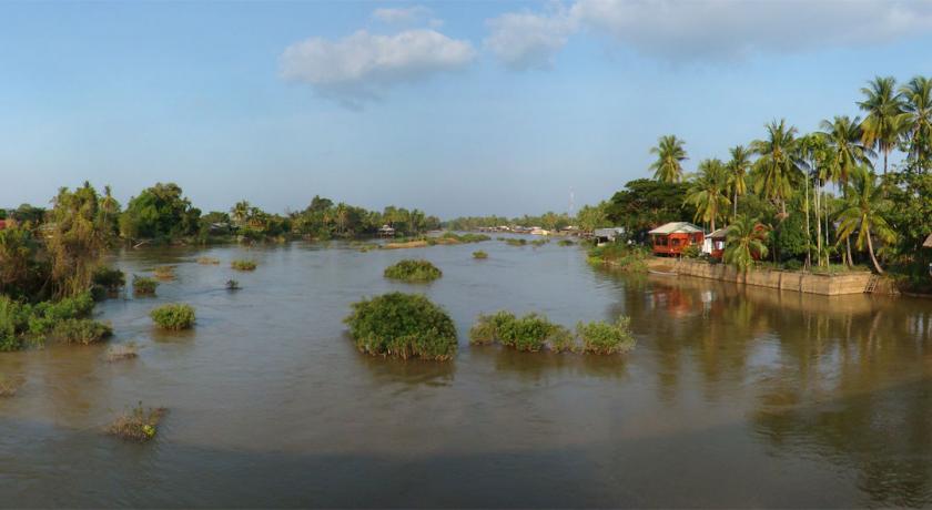
Champasak Province covers an area of 15,415 square kilometers (5,952 sq mi). It is bordered by Salavan Province to the north, Sekong Province to the northeast, Attapeu Province to the east, Cambodia to the south, and Thailand to the west. The river Mekong forms part of the border with neighboring Thailand and contains Si Phan Don (Four Thousand Islands) in the south of the province, on the border with Cambodia.
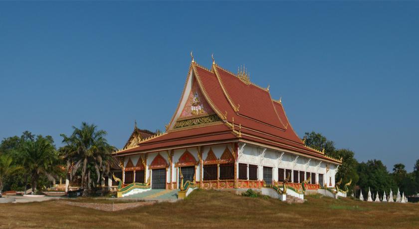
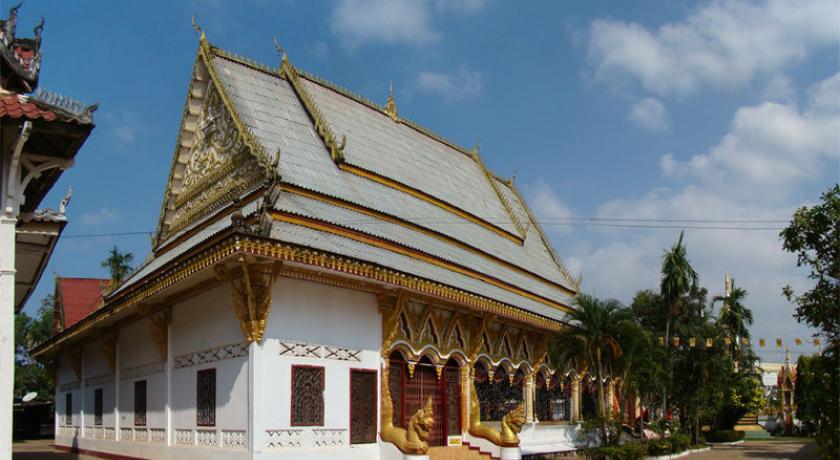
Champasak has played a central role in the history of Siam and Laos, with frequent battles taking place in and around Champasak. Its rich cultural heritage includes ancient temple ruins and French colonial architecture. Champasak has some 20 wats (temples), such as Wat Phou, Wat Luang, and Wat Tham Fai. Freshwater dolphins and the province's many waterfalls are tourist attractions.
History
From the 1st to 9th centuries AD, Champasak province was part of the Funan and then Chenla kingdoms. Between the 10th and 13th centuries it was part of the Khmer Empire. In 1354, the area came under the control of King Fa Ngum and the Lan Xang Empire. The Angkor Empire went into decline between the 15th and 17th centuries when it was annexed by Lan Xang. In 1707, Chamapasak became one of three kingdoms arising from a dissolved Lan Xang Empire. In the 18th century Laos became an independent kingdom. The kingdom had only three emperors, Soi Sisamut (1713–37), nephew of Suriya Vangas, Sainya Kuman (1737–91) and lastly Fai Na (1791–1811). Pakse, the capital of the province, was established by the French in 1905 as an administrative outpost at the confluence of Xe Don (Don River) with the Mekong River.
Geography
Champasak Province covers an area of 15,415 square kilometers (5,952 sq mi). It is bordered by Salavan Province to the north, Sekong Province to the northeast, Attapeu Province to the east, Cambodia to the south, and Thailand to the west. The river Mekong forms part of the border with neighboring Thailand and, after a sharp bend projecting westward, turns east and flows southeasterly through the province down to Cambodia. Champasak can be reached from Thailand through Sirindhorn District's Chong Mek border crossing, to Vang Tao on the Lao side, from where the highway leads east towards the provincial capital Pakse. The capital is situated along Lao's most important highway, Route 13, and the French legacy can be seen in the city's architecture.
Si Phan Don (Four Thousand Islands) is situated in a river stretch of the Mekong, north of the border with Cambodia. Of these islands, Don Khong is the largest and has a number of small villages, temples and caves. A French-built bridge on the abandoned railway line provides the link with two smaller islands, Don Deth and Don Khon.
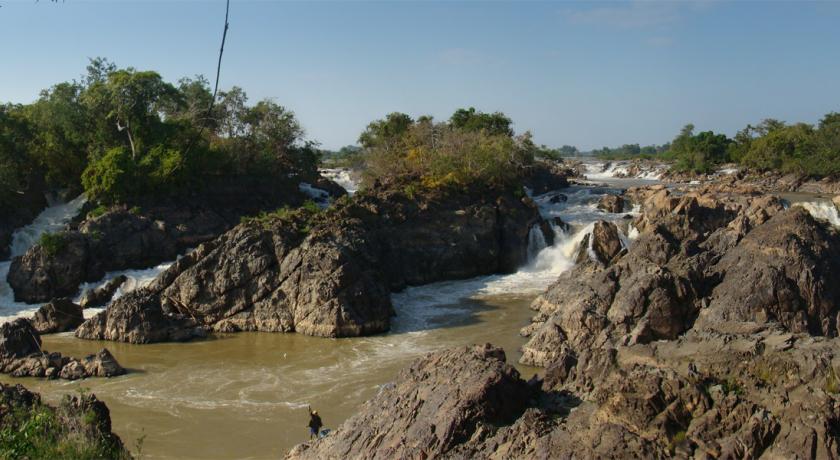
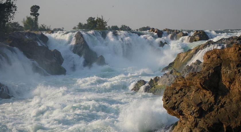
There are many waterfalls in the province such as the Liphi Waterfall at Don Khon to the west of Ban Khon village; below the falls in the calmer waters of the Mekong the fresh water dolphins can be seen. The Khone Phapheng Falls to the east of Don Khon, also on the Mekong, cascade along a broad mouth of rock slopes in a curvilinear pattern. The 120 meters (390 ft) Tad Fane Waterfall (or Dong Hua Sao) in the Bolaven Plateau is the country's highest waterfall. It is created by the Champi and Prakkoot streams which originate at about 1,000 meters (3,300 ft) above sea level. The plateau is situated east of Pakse.
Protected areas
Xe Pian National Biodiversity Conservation Area (NBCA) lies in the southeastern part of the province, while the Dong Hua Sao National Protected Area is in the eastern area. The Center for Protection and Conservation of freshwater dolphins is situated at the Cambodian border. These freshwater dolphins are known locally as “Pakha” in Lao, and are found only on this particular stretch of the Mekong River. Hire boats are available to see these endangered dolphins, either from Ban Khon or Ban Veunkham (located at the southern end of the islands).
The Mekong Channel from Phou Xiang Thong to Siphandon Important Bird Area (IBA) is 34,200 hectares (85,000 acres) in size. A portion of the IBA (10,000 hectares) overlaps with the 120,000 hectares (300,000 acres) Phou Xieng Thong National Protected Area. The IBA encompasses two provinces, Champasak and Salavan. The IBA is situated at an altitude of 40–50 meters (130–160 ft). Its topography consists of earth banks, rocky banks, rocky islands, sandbars, low vegetated islands, rocky islets, and sandy beaches. Notable avifauna includes Laos's last known nesting little terns, river lapwings, river terns, small pratincoles and wire-tailed swallows.
The 36,650 hectares (90,600 acres) Phou Xiang Thong IBA is also situated within the Phou Xiengthong NBCA. This IBA spans two provinces, Champasak and Salavan. The IBA is situated at an altitude of 40–500 meters (130–1,640 ft). The topography consists of low hills, lowlands, rivers, and seasonal streams. Habitat is characterized by dry deciduous tropical forest, moist deciduous tropical forest, and semi-evergreen tropical rainforest, mixed deciduous forest, dry dipterocarp forest, and open rocky savanna. Notable avifauna includes the grey-faced tit-babbler, green peafowl, red-collared woodpecker, and Siamese fireback.
Demographics
The population of the province, as per a March 2005 census, is 607,333. The ethnic group composition consists mainly of Lao, but also Chieng, Inthi, Kaseng, Katang, Kate, Katu, Kien Lavai, Laven, Nge, Nyaheun, Oung, Salao, Suay, Tahang and Tahoy ethnic groups.
Economy
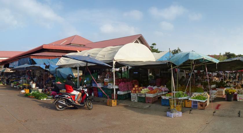
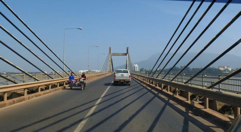
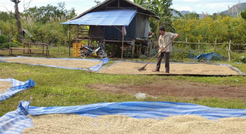
The economic output of the province consist primarily of agricultural products—especially production of coffee, tea, and rattan. It is one of the most important coffee producing areas of Laos along with Salavan and Sekong Provinces. Pakse is the main trade and travel link with Thailand, Cambodia and Vietnam. Following the building of the Lao Nippon Bridge across the Mekong at Pakse in 2002, trade with Thailand has multiplied several folds. The bridge lies at the junction of roads to the Bolaven Plateau in the east, Thailand in the west, and Si Phan Don to the south. Consequently, the market place at the Talat Sao Heung, near the bridge, has become one of the largest in Laos. The weaving centers of Ban Saphai and Don Kho are located 18 kilometers (11 mi) from Pakse. The Jhai Coffee Farmers Cooperative, headquartered at the provincial capital, operates on the Bolaven Plateau. The Bolaven Plateau is also notable for its rubber, tobacco, peaches, pineapple, and rice production.
Get in
Pakse is the transport hub of the region, with an airport, bus service and limited boat access off the Mekong. For Champasak and the South, there are minivans (110,000 kip return to Si Pan Don) bookable from most hotels and tour agents in Pakse town centre. These are nearly always packed; also don't expect any leg room.
Pakse International Airport is north of the city and offers scheduled flights to Vientiane and Siam Reap in Cambodia Lao Air serves Bangkok, Da Nang, Ho Chi Minh City and Siem Reap from Pakse.
The Thai-Lao international bus between Pakse and Ubon Ratchatani (126km, 2 to 3 hrs, Kip 55.000, 2011) is much more comfortable. Busses leave at Pakse at 8.30 am and 3.30 pm, from Ubon Ratchatani at 7.30 am and 3.30 pm. Tickets from Pakse to Bangkok (14 hrs, daily a 3.30 pm, Kip 200.000) and combined bus-sleeper tickets (departure at 3,30 pm, Kip 280.000) are also sold.
From Pakse southern bus station, take a songthaew (starting 9am until 11 am; could be very crowded, 20,000 Kip) to Champasak (~2h) or Than bhan khop (2h15), near the crossing to Wat Phu. In the latter case, you have about 30min walk to Wat Phu entrance.
Motorbike - rent a motorbike in Pakse; head south and cross the Mekong via the Lao-Nippon friendship bridge. After 1.5kms, take a left turn onto a new, excellent condition and quiet road which goes directly to Champasak. It's a scenic ride between the Mekong and Karst formations. You can drive up the road to Wat Phu and stop to taste the various foods the street vendors sell, for foreign traveller with no Laos language skills, it going to be point and hope as little to no English spoken.
Get around
Pakse is on the banks of the Mekong River and is the main town of Southern Laos and capital of Chanmpasak province.
Tourist Office
- Tourist information, Tel 212021, Mon to Fri 8am to noon, 1.30 to 4pm, on the Xe Don River near the Laos Airlines Office, with English speaking staff. The tourist information can organize trekking to the Xe Pian and Phou Xieng Thong nature reserves and overnight stays with natives at Don Kho and Don Daeng.
Set in stunning natural surroundings, Vat Phou, the ancient Khmer temple complex, listed as a UNESCO World Heritage site, is the main attraction in the area, but there is much more to be discovered. It is worth staying in the charming town of Champasak where you can discover French colonial buildings, Buddhist temples, or simply enjoy an evening in the Shadow Puppet Theatre. You could also take a relaxing massage at the Spa or take a boat to the Mekong island of Don Daeng to relax in its tranquil environment and discover local village life on a bicycle.
Most places in Champasak, including Wat Phou, can be visited as day trips from Pakse.
See
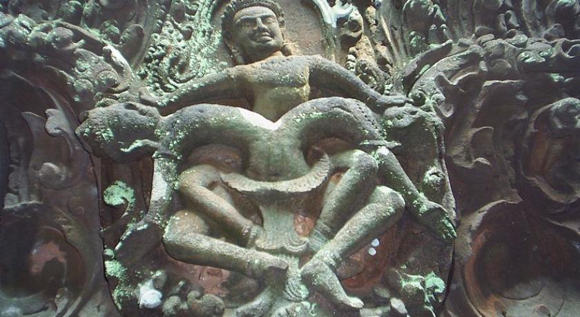
- Wat Phu (Vat Phou). A c. 12th century Hindu temple built in the days of the Khmer Empire in the style of Angkor. The temple is still in use as a Buddhist site. The park is only open during certain hours (such as 9am to 4:30 pm.). 50,000 Kip for temple and museum and 15,000 for golf car (the entrance gate is far from the temple about 800 meters).
- Wat Nang sida 2 km from Wat Phu on the ancient road to Angkor Wat. Big ruins with massive big stones under reconstruction.
- ruins of medium size temple 1km from the previous one, difficult access on dirt road and forest. To Mo ruins on the other side of the Mekong.
- sacred mountain (1416mt.). The top has a natural stone lingam of 10mt which can be seen from the bottom of Wat Phu. Impossible to reach the top; maybe with 2-3 days trek.
All these sites have the status of UNESCO world heritage.
- Khone waterfalls on the border with Cambodia.
Source https://en.wikipedia.org/wiki/Champasak_Province
Address
Champasak Province
Laos
Lat: 14.657866478 - Lng: 105.969985962

